


- Description
- Specifications
- Reviews (0)
Description
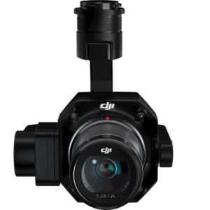
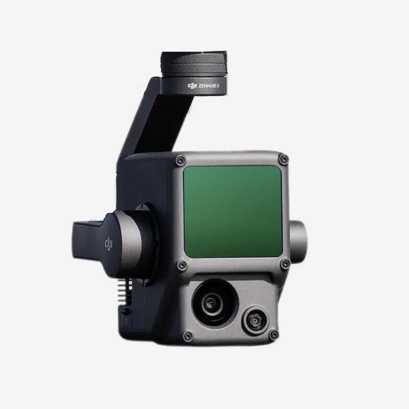
DJI Zenmuse P1 – Precision, Power, and Perfection in Aerial Surveying!
Imagine having a full-frame 45MP camera strapped to your drone, delivering unparalleled accuracy and efficiency in aerial surveying. That’s exactly what the DJI Zenmuse P1 does! Designed for high-end photogrammetry, this beast of a payload revolutionizes how we capture aerial data. Whether you’re mapping vast landscapes, conducting high-precision land surveys, or inspecting large infrastructures, the P1 ensures maximum accuracy with minimal effort. If you thought aerial surveying was slow, tedious, and complex, get ready to experience a whole new level of speed and efficiency!
Why the Zenmuse P1 is an Absolute Game-Changer?
1. 45MP Full-Frame Sensor – The King of Aerial Photography!
When it comes to aerial mapping, resolution matters—and the Zenmuse P1 doesn’t disappoint. Packed with a massive 45MP full-frame sensor, it captures high-resolution images that make even the tiniest details stand out. Whether you’re mapping construction sites, agricultural fields, or historical monuments, this sensor ensures crystal-clear results with stunning detail. More pixels mean better accuracy, sharper images, and more data per flight, so you can cover larger areas without losing precision!
2. Global Mechanical Shutter – Say Goodbye to Motion Blur!
Ever captured an image mid-flight only to realize it’s blurry? That’s because rolling shutters struggle with high-speed motion. The Zenmuse P1 features a global mechanical shutter with an ultra-fast shutter speed of 1/2000s, ensuring every image is pin-sharp—even when your drone is flying at top speed. Whether you’re capturing high-speed infrastructure inspections or detailed 3D models, this shutter ensures zero distortion, no rolling shutter effects, and absolute clarity in every shot!
3. Smart Oblique Capture – Cover More, Fly Less!
Why take extra flights when you can capture everything in one go? The Smart Oblique Capture mode enables the P1 to automatically tilt and rotate the camera, capturing images from multiple angles in a single pass. This means you cover larger areas faster while ensuring high-quality 3D reconstructions. Whether you’re creating city-scale 3D models or mapping rugged terrain, this feature saves time, reduces flight costs, and maximizes efficiency.
4. 3-Axis Gimbal – Ultra-Stable, Pinpoint Accuracy!
Even the best camera is useless if it can’t hold steady. That’s why the P1 comes equipped with a high-precision 3-axis gimbal, ensuring every shot is perfectly level and ultra-stable. No more shaky images or misaligned data—just smooth, professional-grade imagery that makes processing faster and easier. Whether you’re flying in windy conditions or at high altitudes, the P1’s gimbal ensures your images remain rock-solid!
5. Large Area Coverage – Survey More in Less Time!
Time is money, and the Zenmuse P1 knows it. With its full-frame sensor and large field of view, it covers 3 km² in a single flight—that’s up to 4 times more than traditional cameras! Whether you’re mapping entire cities, highways, or forests, this camera ensures you capture more with fewer flights, saving time and reducing operational costs. If efficiency had a name, it would be Zenmuse P1!
6. RTK for Absolute Accuracy – Pinpoint Precision Every Time!
Aerial mapping is only useful if the data is accurate. That’s why the Zenmuse P1 is equipped with RTK (Real-Time Kinematics), delivering centimeter-level accuracy without the need for ground control points. Whether you’re mapping infrastructure, planning urban development, or monitoring environmental changes, the RTK system ensures every image is geo-tagged with pinpoint precision. No more guesswork—just flawless, high-precision mapping!
7. Interchangeable Lenses – Adapt to Any Mission!
Different projects require different lenses, and the Zenmuse P1 lets you swap between 24mm, 35mm, and 50mm lenses for maximum flexibility. Need wide-area coverage? Use the 24mm lens. Want ultra-detailed shots for structural inspections? The 50mm lens has got you covered. No matter the mission, the P1 adapts like a pro!
8. IP4X Weather Resistance – Ready for Any Environment!
Rain, dust, and harsh conditions won’t stop the Zenmuse P1 from getting the job done. With its IP4X-rated weather resistance, it’s built to perform in challenging environments. Whether you’re surveying rocky terrains, coastal areas, or remote locations, the P1 ensures you get reliable results—no matter the conditions!
How to Use the Zenmuse P1 Like a Pro?
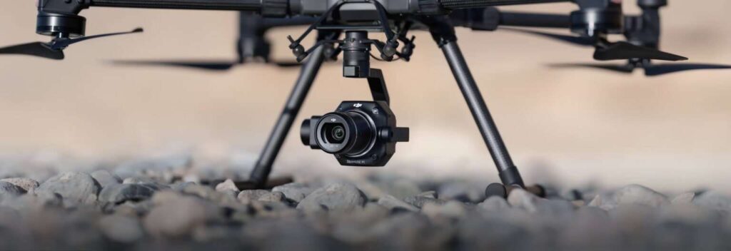
1. Mount It on the Matrice 300 RTK – Seamless Integration!
The Zenmuse P1 is designed to work flawlessly with the DJI Matrice 300 RTK. Just attach it, connect to DJI Pilot, and you’re ready to map with unmatched precision!
2. Select the Right Flight Mode – Optimize Your Workflow!
Choose from various flight modes based on your project:
-
Mapping Mode – Ideal for 2D aerial mapping missions.
-
Oblique Mode – Captures images at different angles for 3D modeling.
-
Linear Mode – Perfect for corridor mapping (roads, pipelines, railways).
With pre-set automation and smart route planning, the P1 makes surveying easier than ever!
3. Start Capturing – Let the Camera Do the Work!
Once airborne, the Zenmuse P1 captures images with centimeter-level accuracy. With its high-speed shutter, RTK integration, and oblique capture mode, every shot is flawless, stable, and ultra-precise!
4. Process Data in DJI Terra – Turn Images into 3D Models!
After the flight, import your data into DJI Terra for fast processing. The software automatically stitches images together, creating detailed 2D maps and 3D models with minimal effort. Whether you need high-resolution maps, volumetric calculations, or elevation models, DJI Terra makes it easy and efficient!
5. Export & Use – Ready for Your Next Big Project!
Once processed, export your maps and models to GIS, CAD, or engineering software. Whether you’re planning construction, conducting environmental studies, or managing land development, the Zenmuse P1 ensures your data is accurate, reliable, and ready for action!
How to Take Care of Your Zenmuse P1 – Keep It Running Like New!
1. Clean the Lens Regularly – A dirty lens means blurry images. Use a microfiber cloth to keep the camera and lens spotless before every flight.
2. Store in a Protective Case – Protect your investment by storing the P1 in a shockproof, waterproof case when not in use.
3. Keep Firmware Updated – DJI frequently releases firmware updates that improve stability, accuracy, and new features—always stay updated!
4. Avoid Extreme Conditions – Excessive heat or cold can affect performance, so always operate within the recommended temperature range.
5. Inspect Before Every Flight – Before takeoff, check for loose components, lens alignment, and any potential damage to ensure flawless operation!
Upgrade Your Aerial Surveying Game – Get the DJI Zenmuse P1 Today!
If you’re looking for the ultimate photogrammetry camera for aerial surveying, the Zenmuse P1 is the industry leader. Stop wasting time on low-resolution data and slow mapping methods—upgrade to the P1 and experience next-level precision today!
Be the first to review “Zenmuse P1”
DJI Zenmuse P1 – Precision, Power, and Perfection in Aerial Surveying!
Imagine having a full-frame 45MP camera strapped to your drone, delivering unparalleled accuracy and efficiency in aerial surveying. That’s exactly what the DJI Zenmuse P1 does! Designed for high-end photogrammetry, this beast of a payload revolutionizes how we capture aerial data. Whether you’re mapping vast landscapes, conducting high-precision land surveys, or inspecting large infrastructures, the P1 ensures maximum accuracy with minimal effort. If you thought aerial surveying was slow, tedious, and complex, get ready to experience a whole new level of speed and efficiency!
Why the Zenmuse P1 is an Absolute Game-Changer?
1. 45MP Full-Frame Sensor – The King of Aerial Photography!
When it comes to aerial mapping, resolution matters—and the Zenmuse P1 doesn’t disappoint. Packed with a massive 45MP full-frame sensor, it captures high-resolution images that make even the tiniest details stand out. Whether you’re mapping construction sites, agricultural fields, or historical monuments, this sensor ensures crystal-clear results with stunning detail. More pixels mean better accuracy, sharper images, and more data per flight, so you can cover larger areas without losing precision!
2. Global Mechanical Shutter – Say Goodbye to Motion Blur!
Ever captured an image mid-flight only to realize it’s blurry? That’s because rolling shutters struggle with high-speed motion. The Zenmuse P1 features a global mechanical shutter with an ultra-fast shutter speed of 1/2000s, ensuring every image is pin-sharp—even when your drone is flying at top speed. Whether you’re capturing high-speed infrastructure inspections or detailed 3D models, this shutter ensures zero distortion, no rolling shutter effects, and absolute clarity in every shot!
3. Smart Oblique Capture – Cover More, Fly Less!
Why take extra flights when you can capture everything in one go? The Smart Oblique Capture mode enables the P1 to automatically tilt and rotate the camera, capturing images from multiple angles in a single pass. This means you cover larger areas faster while ensuring high-quality 3D reconstructions. Whether you’re creating city-scale 3D models or mapping rugged terrain, this feature saves time, reduces flight costs, and maximizes efficiency.
4. 3-Axis Gimbal – Ultra-Stable, Pinpoint Accuracy!
Even the best camera is useless if it can’t hold steady. That’s why the P1 comes equipped with a high-precision 3-axis gimbal, ensuring every shot is perfectly level and ultra-stable. No more shaky images or misaligned data—just smooth, professional-grade imagery that makes processing faster and easier. Whether you’re flying in windy conditions or at high altitudes, the P1’s gimbal ensures your images remain rock-solid!
5. Large Area Coverage – Survey More in Less Time!
Time is money, and the Zenmuse P1 knows it. With its full-frame sensor and large field of view, it covers 3 km² in a single flight—that’s up to 4 times more than traditional cameras! Whether you’re mapping entire cities, highways, or forests, this camera ensures you capture more with fewer flights, saving time and reducing operational costs. If efficiency had a name, it would be Zenmuse P1!
6. RTK for Absolute Accuracy – Pinpoint Precision Every Time!
Aerial mapping is only useful if the data is accurate. That’s why the Zenmuse P1 is equipped with RTK (Real-Time Kinematics), delivering centimeter-level accuracy without the need for ground control points. Whether you’re mapping infrastructure, planning urban development, or monitoring environmental changes, the RTK system ensures every image is geo-tagged with pinpoint precision. No more guesswork—just flawless, high-precision mapping!
7. Interchangeable Lenses – Adapt to Any Mission!
Different projects require different lenses, and the Zenmuse P1 lets you swap between 24mm, 35mm, and 50mm lenses for maximum flexibility. Need wide-area coverage? Use the 24mm lens. Want ultra-detailed shots for structural inspections? The 50mm lens has got you covered. No matter the mission, the P1 adapts like a pro!
8. IP4X Weather Resistance – Ready for Any Environment!
Rain, dust, and harsh conditions won’t stop the Zenmuse P1 from getting the job done. With its IP4X-rated weather resistance, it’s built to perform in challenging environments. Whether you’re surveying rocky terrains, coastal areas, or remote locations, the P1 ensures you get reliable results—no matter the conditions!
How to Use the Zenmuse P1 Like a Pro?
1. Mount It on the Matrice 300 RTK – Seamless Integration!
The Zenmuse P1 is designed to work flawlessly with the DJI Matrice 300 RTK. Just attach it, connect to DJI Pilot, and you’re ready to map with unmatched precision!
2. Select the Right Flight Mode – Optimize Your Workflow!
Choose from various flight modes based on your project:
-
Mapping Mode – Ideal for 2D aerial mapping missions.
-
Oblique Mode – Captures images at different angles for 3D modeling.
-
Linear Mode – Perfect for corridor mapping (roads, pipelines, railways).
With pre-set automation and smart route planning, the P1 makes surveying easier than ever!
3. Start Capturing – Let the Camera Do the Work!
Once airborne, the Zenmuse P1 captures images with centimeter-level accuracy. With its high-speed shutter, RTK integration, and oblique capture mode, every shot is flawless, stable, and ultra-precise!
4. Process Data in DJI Terra – Turn Images into 3D Models!
After the flight, import your data into DJI Terra for fast processing. The software automatically stitches images together, creating detailed 2D maps and 3D models with minimal effort. Whether you need high-resolution maps, volumetric calculations, or elevation models, DJI Terra makes it easy and efficient!
5. Export & Use – Ready for Your Next Big Project!
Once processed, export your maps and models to GIS, CAD, or engineering software. Whether you’re planning construction, conducting environmental studies, or managing land development, the Zenmuse P1 ensures your data is accurate, reliable, and ready for action!
How to Take Care of Your Zenmuse P1 – Keep It Running Like New!
1. Clean the Lens Regularly – A dirty lens means blurry images. Use a microfiber cloth to keep the camera and lens spotless before every flight.
2. Store in a Protective Case – Protect your investment by storing the P1 in a shockproof, waterproof case when not in use.
3. Keep Firmware Updated – DJI frequently releases firmware updates that improve stability, accuracy, and new features—always stay updated!
4. Avoid Extreme Conditions – Excessive heat or cold can affect performance, so always operate within the recommended temperature range.
5. Inspect Before Every Flight – Before takeoff, check for loose components, lens alignment, and any potential damage to ensure flawless operation!
Upgrade Your Aerial Surveying Game – Get the DJI Zenmuse P1 Today!
If you’re looking for the ultimate photogrammetry camera for aerial surveying, the Zenmuse P1 is the industry leader. Stop wasting time on low-resolution data and slow mapping methods—upgrade to the P1 and experience next-level precision today!
Air-Dropping System for DJI Air 3 / Air 3S


Zenmuse L3

Reviews
There are no reviews yet.