


- Description
- Specifications
- Reviews (0)
Description
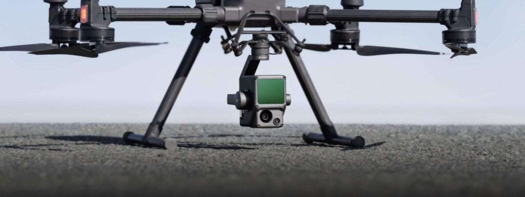
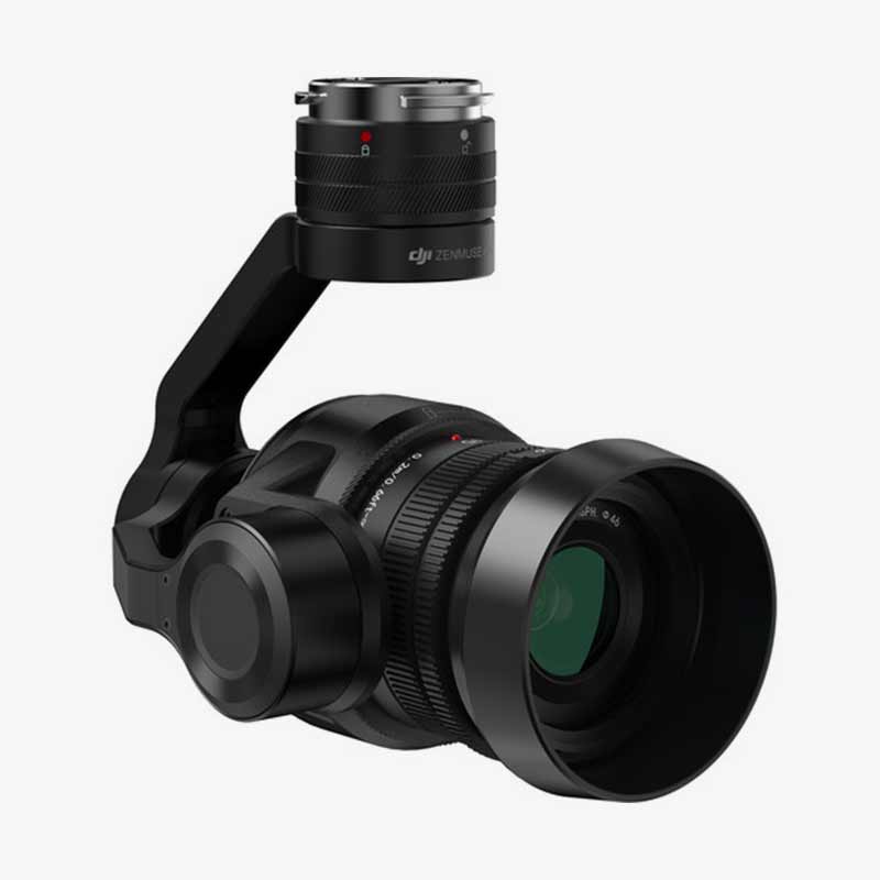
DJI Zenmuse L1 – Turn Your Drone into a 3D Mapping Powerhouse!
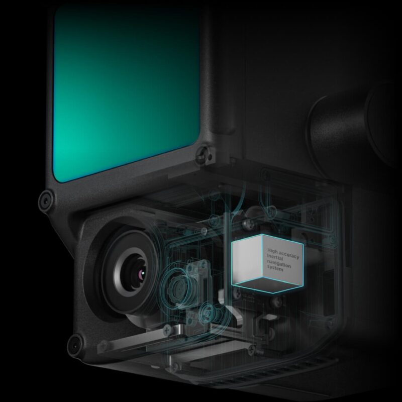
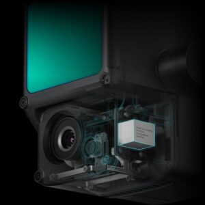
Imagine if your drone had X-ray vision, the precision of a laser, and the ability to scan entire landscapes in minutes. That’s exactly what the DJI Zenmuse L1 brings to the table! Whether you’re mapping dense forests, inspecting large infrastructure, or conducting high-precision land surveys, this LiDAR-powered camera turns your drone into a flying surveyor. With cutting-edge LiDAR, a 20MP RGB camera, and an IMU, the Zenmuse L1 ensures you get accurate 3D models in real time. If you thought mapping was time-consuming, this game-changer will make you rethink everything.
Why the Zenmuse L1 is a Game-Changer?
1. High-Precision LiDAR – See Through Trees Like a Super Scanner!
Most cameras struggle when there’s too much vegetation, but the Zenmuse L1’s LiDAR laughs at obstacles. Using laser pulses, it cuts through trees, bushes, and even tricky terrain, giving you an ultra-detailed 3D map. Whether you’re surveying forests, measuring elevation changes, or inspecting hidden structures, this LiDAR system ensures you don’t miss a single detail. It’s like turning your drone into a high-tech scanner that sees what the human eye can’t. If you ever wanted to map an entire jungle without stepping inside, now’s your chance!
2. 240,000 Points Per Second – Because More Data Means More Accuracy!
Forget blurry images and unreliable measurements—the L1 captures a mind-blowing 240,000 points per second! This means ultra-dense point clouds that create highly accurate digital elevation models. Whether you’re mapping a large construction site, assessing disaster damage, or analyzing land topography, this LiDAR system captures every bump, dip, and contour with extreme precision. Think of it as painting a 3D picture, but with lasers and insane accuracy!
3. 20MP RGB Camera – Crystal Clear Images for Ultimate Mapping!
Why settle for just LiDAR data when you can have stunning visuals too? The Zenmuse L1 comes with a powerful 20MP RGB camera that works alongside LiDAR to provide rich textures and real-world colors. This means your 3D maps won’t just be accurate—they’ll look amazing too! Whether you’re surveying land, documenting construction progress, or creating detailed visual reports, this camera ensures you capture every fine detail in high resolution. No more guessing what those blurry pixels are—now you’ll see everything with crystal clarity!
4. IMU for Real-Time Accuracy – No More Data Headaches!
Mapping is useless if your data isn’t accurate, and that’s where the L1’s high-precision IMU (Inertial Measurement Unit) comes in. It constantly tracks the drone’s position, tilt, and movement, ensuring that every LiDAR point is perfectly aligned. Whether you’re flying over mountains, valleys, or rugged terrain, your data will always be precisely calibrated—saving you hours of post-processing work! It’s like having a super-intelligent assistant making sure everything stays perfectly accurate, no matter how tricky the flight path gets.
5. Real-Time 3D Mapping – See Your Data Instantly!
Why wait until you land to see the results? With real-time 3D point cloud generation, you can view your data while still in the air! This means you can adjust flight paths, fix missing details, and get instant insights without wasting time. Whether you’re working in disaster response, land surveying, or infrastructure inspection, this feature ensures you can make critical decisions on the spot, without waiting for post-processing delays. It’s like having a live 3D printer for your maps—but in the sky!
6. IP54 Weather Resistance – Rain, Dust, or Wind? No Problem!
A great mapping camera is useless if it can’t handle real-world conditions. That’s why the Zenmuse L1 is built to withstand dust, rain, and harsh environments with its IP54 weather rating. Whether you’re mapping a construction site during a storm, scanning a forest in the heat, or flying in strong winds, this camera keeps going like a true warrior. Because when you’re working in the field, you need gear that won’t quit on you!
How to Use the Zenmuse L1 Like a Pro?
1. Attach It to Your Matrice 300 RTK – Plug, Play & Fly!
First, mount the Zenmuse L1 onto your DJI Matrice 300 RTK—no complicated setup required! This seamless integration allows you to start mapping right away. Just connect, calibrate, and get ready to scan landscapes like a futuristic explorer!
2. Choose the Right Flight Mode – Mapping Made Easy!
Depending on your mission, select from different flight modes:
-
Waypoints Mode – Perfect for pre-planned, high-precision mapping routes.
-
Terrain Follow Mode – Automatically adjusts altitude to maintain accuracy over uneven surfaces.
-
Live 3D Mode – Instantly generate 3D maps in real-time while flying!
Pick the mode that best suits your project, and let the L1 handle the rest. No rocket science needed—just pure mapping magic!
3. Start Capturing Data – Let LiDAR Do the Heavy Lifting!
Once in the air, the Zenmuse L1 does all the hard work for you. Just start your mission, and watch as it scans, collects, and processes ultra-detailed data. With its high-speed LiDAR, precision IMU, and 20MP camera, every pass ensures a complete and accurate scan—no second flights required!
4. Process Your Data in DJI Terra – Turn Raw Data into Stunning 3D Models!
After landing, import your LiDAR data into DJI Terra for easy and fast processing. The software automatically stitches together point clouds, applies textures, and creates precise 3D maps, saving you hours of work. Whether you’re creating topographical surveys, flood analysis maps, or ultra-realistic 3D city models, this software turns complex data into clear, actionable results!
5. Export & Share – Ready for Action!
Once processed, export your 3D maps, terrain models, and point cloud data to your preferred format—ready for CAD, GIS, or engineering software. Whether you need to plan new infrastructure, analyze environmental changes, or improve construction workflows, your Zenmuse L1-generated data is ready to go!
How to Take Care of Your Zenmuse L1 – Keep It Running Like New!
1. Keep the LiDAR Lens Clean – Dust and smudges can mess with your scans, so use a microfiber cloth to keep the LiDAR and RGB camera spotless. A little cleaning before every flight keeps your data crisp and accurate!
2. Store in a Shockproof Case – The Zenmuse L1 is a high-tech powerhouse, so store it safely in a padded, waterproof case to avoid damage from bumps, drops, or bad weather.
3. Update Firmware Regularly – DJI frequently releases software updates that improve accuracy, stability, and performance. Always check for firmware updates to ensure your L1 is running at peak efficiency!
4. Avoid Extreme Temperatures – While it’s built tough, exposing it to excessive heat or extreme cold can affect performance. Always operate within the recommended temperature range to keep your LiDAR and IMU working perfectly!
5. Inspect Before Every Flight – Before every flight, check for loose parts, sensor alignment, and any potential damage. This ensures your Zenmuse L1 is always mission-ready!
Take Your Mapping to the Next Level – Get the DJI Zenmuse L1 Today!
If you’re serious about professional aerial mapping, LiDAR scanning, or high-precision surveying, the Zenmuse L1 is the ultimate tool for the job. Stop wasting time on outdated methods and upgrade to cutting-edge LiDAR technology today!
Specifications Of Zenmuse L1
| Specification | Details |
|---|---|
| Product Name | Zenmuse L1 |
| Compatible Drones | DJI Matrice 300 RTK, Matrice 350 RTK |
| LiDAR Sensor | Livox LiDAR module |
| Point Cloud Accuracy | Vertical: 5 cm, Horizontal: 10 cm |
| Maximum Detection Range | 450m @ 80% reflectivity, 190m @ 10% reflectivity |
| Laser Scanning Rate | 240,000 points per second |
| Field of View (FoV) | 70.4° × 77.2° |
| RGB Camera | 20 MP, 1-inch CMOS sensor, Mechanical Shutter |
| IMU Accuracy | High-precision IMU for georeferencing |
| Real-Time Processing | Live 3D point cloud generation with DJI Terra |
| Environmental Rating | IP54 (Dust and Water Resistant) |
| Operating Temperature | -20°C to 50°C |
| Weight | Approx. 900g |
| Data Storage | Supports MicroSD Cards up to 256GB |
| Software Compatibility | DJI Terra, Third-Party GIS Software |
| Application Areas | Surveying, Mapping, Forestry, Infrastructure Inspection |
Be the first to review “Zenmuse L1”
DJI Zenmuse L1 – Turn Your Drone into a 3D Mapping Powerhouse!
Imagine if your drone had X-ray vision, the precision of a laser, and the ability to scan entire landscapes in minutes. That’s exactly what the DJI Zenmuse L1 brings to the table! Whether you’re mapping dense forests, inspecting large infrastructure, or conducting high-precision land surveys, this LiDAR-powered camera turns your drone into a flying surveyor. With cutting-edge LiDAR, a 20MP RGB camera, and an IMU, the Zenmuse L1 ensures you get accurate 3D models in real time. If you thought mapping was time-consuming, this game-changer will make you rethink everything.
Why the Zenmuse L1 is a Game-Changer?
1. High-Precision LiDAR – See Through Trees Like a Super Scanner!
Most cameras struggle when there’s too much vegetation, but the Zenmuse L1’s LiDAR laughs at obstacles. Using laser pulses, it cuts through trees, bushes, and even tricky terrain, giving you an ultra-detailed 3D map. Whether you’re surveying forests, measuring elevation changes, or inspecting hidden structures, this LiDAR system ensures you don’t miss a single detail. It’s like turning your drone into a high-tech scanner that sees what the human eye can’t. If you ever wanted to map an entire jungle without stepping inside, now’s your chance!
2. 240,000 Points Per Second – Because More Data Means More Accuracy!
Forget blurry images and unreliable measurements—the L1 captures a mind-blowing 240,000 points per second! This means ultra-dense point clouds that create highly accurate digital elevation models. Whether you’re mapping a large construction site, assessing disaster damage, or analyzing land topography, this LiDAR system captures every bump, dip, and contour with extreme precision. Think of it as painting a 3D picture, but with lasers and insane accuracy!
3. 20MP RGB Camera – Crystal Clear Images for Ultimate Mapping!
Why settle for just LiDAR data when you can have stunning visuals too? The Zenmuse L1 comes with a powerful 20MP RGB camera that works alongside LiDAR to provide rich textures and real-world colors. This means your 3D maps won’t just be accurate—they’ll look amazing too! Whether you’re surveying land, documenting construction progress, or creating detailed visual reports, this camera ensures you capture every fine detail in high resolution. No more guessing what those blurry pixels are—now you’ll see everything with crystal clarity!
4. IMU for Real-Time Accuracy – No More Data Headaches!
Mapping is useless if your data isn’t accurate, and that’s where the L1’s high-precision IMU (Inertial Measurement Unit) comes in. It constantly tracks the drone’s position, tilt, and movement, ensuring that every LiDAR point is perfectly aligned. Whether you’re flying over mountains, valleys, or rugged terrain, your data will always be precisely calibrated—saving you hours of post-processing work! It’s like having a super-intelligent assistant making sure everything stays perfectly accurate, no matter how tricky the flight path gets.
5. Real-Time 3D Mapping – See Your Data Instantly!
Why wait until you land to see the results? With real-time 3D point cloud generation, you can view your data while still in the air! This means you can adjust flight paths, fix missing details, and get instant insights without wasting time. Whether you’re working in disaster response, land surveying, or infrastructure inspection, this feature ensures you can make critical decisions on the spot, without waiting for post-processing delays. It’s like having a live 3D printer for your maps—but in the sky!
6. IP54 Weather Resistance – Rain, Dust, or Wind? No Problem!
A great mapping camera is useless if it can’t handle real-world conditions. That’s why the Zenmuse L1 is built to withstand dust, rain, and harsh environments with its IP54 weather rating. Whether you’re mapping a construction site during a storm, scanning a forest in the heat, or flying in strong winds, this camera keeps going like a true warrior. Because when you’re working in the field, you need gear that won’t quit on you!
How to Use the Zenmuse L1 Like a Pro?
1. Attach It to Your Matrice 300 RTK – Plug, Play & Fly!
First, mount the Zenmuse L1 onto your DJI Matrice 300 RTK—no complicated setup required! This seamless integration allows you to start mapping right away. Just connect, calibrate, and get ready to scan landscapes like a futuristic explorer!
2. Choose the Right Flight Mode – Mapping Made Easy!
Depending on your mission, select from different flight modes:
-
Waypoints Mode – Perfect for pre-planned, high-precision mapping routes.
-
Terrain Follow Mode – Automatically adjusts altitude to maintain accuracy over uneven surfaces.
-
Live 3D Mode – Instantly generate 3D maps in real-time while flying!
Pick the mode that best suits your project, and let the L1 handle the rest. No rocket science needed—just pure mapping magic!
3. Start Capturing Data – Let LiDAR Do the Heavy Lifting!
Once in the air, the Zenmuse L1 does all the hard work for you. Just start your mission, and watch as it scans, collects, and processes ultra-detailed data. With its high-speed LiDAR, precision IMU, and 20MP camera, every pass ensures a complete and accurate scan—no second flights required!
4. Process Your Data in DJI Terra – Turn Raw Data into Stunning 3D Models!
After landing, import your LiDAR data into DJI Terra for easy and fast processing. The software automatically stitches together point clouds, applies textures, and creates precise 3D maps, saving you hours of work. Whether you’re creating topographical surveys, flood analysis maps, or ultra-realistic 3D city models, this software turns complex data into clear, actionable results!
5. Export & Share – Ready for Action!
Once processed, export your 3D maps, terrain models, and point cloud data to your preferred format—ready for CAD, GIS, or engineering software. Whether you need to plan new infrastructure, analyze environmental changes, or improve construction workflows, your Zenmuse L1-generated data is ready to go!
How to Take Care of Your Zenmuse L1 – Keep It Running Like New!
1. Keep the LiDAR Lens Clean – Dust and smudges can mess with your scans, so use a microfiber cloth to keep the LiDAR and RGB camera spotless. A little cleaning before every flight keeps your data crisp and accurate!
2. Store in a Shockproof Case – The Zenmuse L1 is a high-tech powerhouse, so store it safely in a padded, waterproof case to avoid damage from bumps, drops, or bad weather.
3. Update Firmware Regularly – DJI frequently releases software updates that improve accuracy, stability, and performance. Always check for firmware updates to ensure your L1 is running at peak efficiency!
4. Avoid Extreme Temperatures – While it’s built tough, exposing it to excessive heat or extreme cold can affect performance. Always operate within the recommended temperature range to keep your LiDAR and IMU working perfectly!
5. Inspect Before Every Flight – Before every flight, check for loose parts, sensor alignment, and any potential damage. This ensures your Zenmuse L1 is always mission-ready!
Take Your Mapping to the Next Level – Get the DJI Zenmuse L1 Today!
If you’re serious about professional aerial mapping, LiDAR scanning, or high-precision surveying, the Zenmuse L1 is the ultimate tool for the job. Stop wasting time on outdated methods and upgrade to cutting-edge LiDAR technology today!


Reviews
There are no reviews yet.